Snow, wintry mix continues in southern New Hampshire through Friday morning
GOOD IS THE MOST REWARDING PART OF HIS CAREER. LET’S GET A LIVE LOOK ON THE ROADS NOW FROM STORM TRACKER AND YOU CAN SEE THIS IS THE MANCHESTER AREA. YEAH, THERE IS THAT SLEET. MIKE WAS TALKING ABOUT. YOU CAN SEE THE TIRE TRACKS, BUT OTHERWISE. I’M GOING TO BE SOME MESSY DRIVING. ALL RIGHT, LET’S BRING IN CHIEF METEOROLOGIST MIKE HADDAD NOW. AND MIKE, IT’S KIND OF A MIX OF EVERYTHING. THERE’S THE SLEET. THERE’S ALSO THE CHANCE FOR, YOU KNOW, THAT COLD RAIN AND THE CHANCE FOR SNOW, TOO. YEAH. IT’S JUST A SMORGASBORD OF WEATHER EXCITEMENT HERE. IF YOU’RE NOT ON THE ROAD, STEVE. RIGHT. BECAUSE YOU JUST NOTICED THEY’RE NOT SNOW, BUT SLEET CREATING THAT SLUSH. AND IT’S GOING TO BE SLIPPERY ALL THE WAY THROUGH THE MORNING DRIVE TOMORROW, INCLUDING RIGHT HERE IN THE QUEEN CITY. NOTICE RIGHT NOW THE FLAGS ARE STILL, THE WINDS ARE LIGHT, BUT THERE IS SOME SLEET FALLING. IT’S THOSE PELLETS OF ICE THAT BASICALLY FORM AS RAIN IN THE CLOUD LAYER, BECAUSE IT’S TOO WARM UP THERE FOR SNOW TO FORM. BUT AS IT FALLS DOWN THROUGH THE CLOUD AND EVENTUALLY APPROACHES THE GROUND, IT FREEZES BEFORE REACHING THE GROUND, AND THAT CAUSES THAT LITTLE ICE PELLET TO FORM. IF IT WAITS UNTIL ACTUALLY HITTING THE GROUND. WE CALL THAT FREEZING RAIN. AND THAT’S THE THING THAT BASICALLY GLOPS ONTO THE POWER LINES AND THE TREES AND RESULTS IN POWER OUTAGES. WE DON’T HAVE THAT. THANKFULLY, AS A WIDESPREAD PROBLEM TONIGHT, BUT RIGHT NOW WE’RE FREEZING IN MANY SPOTS, INCLUDING ALL OF THE MERRIMACK VALLEY UP TO LACONIA, THE UPPER VALLEY SOUTH OVER TO THE COASTLINE. AND THAT’S WHERE PRECIPITATION IS FALLING. SO IMPACT WEATHER, PERIODS OF SNOW AND SOME ICING AT TIMES. CENTRAL AND SOUTH SLICK ROADS ALREADY THAT LINGERS INTO THE MORNING DRIVE TOMORROW. AGAIN, THE FOCUS HERE LAKES REGION AND POINTS SOUTH. SO NOTICE THE DOPPLER RADAR. WE’VE GOT BLUE AND PURPLE. WHAT DOES IT MEAN? MEANS FROZEN PRECIPITATION. AND THAT’S BAD FOR TRAVELING. SO SOME SLEET MIXING IN WITH THE WET SNOW. AT TIMES IT GOES FROM WET SNOW OVER TO SLEET. BUT I THINK WHAT’S GOING TO HAPPEN IN THE NEXT COUPLE OF HOURS, ALL OF THIS IN NEW YORK STATE. NOTICE UNDERNEATH THE PINK HERE THESE LITTLE BANDS OF ORANGE AND RED INDICATING HEAVIER PRECIPITATION. AS THAT MOVES ON IN IT’S GOING TO COOL THE ATMOSPHERE ENOUGH TO CHANGE IT OVER TO ALL WET SNOW. AND THAT’S WHY I’M EXPECTING AT LEAST 3 OR 4IN OF WET SNOW IN THE COMING HOURS. CENTRAL AND SOUTHERN PARTS OF THE STATE PACKAGE ALREADY MOVING THROUGH BUFFALO. THAT’S IN HERE AND OUT OF HERE BY ABOUT 8 OR 9 IN THE MORNING TOMORROW. NOTHING HAPPENING FOR THE NORTH. IF YOU’RE IN THE GREAT NORTH WOODS, MOUNT WASHINGTON VALLEY, FRANCONIA NOTCH, MAYBE A FLURRY. OUTSIDE OF THAT, IT’S ALL HAPPENING FARTHER OFF TO THE SOUTH, BUT DONE BY ABOUT NINE IN THE MORNING. IN TERMS OF WHAT HAPPENS AFTER THAT, THE CLOUDS LINGER TOMORROW AFTERNOON. LIGHT WINDS ONSHORE, A BIT OF DRIZZLE, MAYBE POCKETS OF FREEZING DRIZZLE. NOT A WIDESPREAD PROBLEM ON THE ROADS BECAUSE WE’LL BE NEAR 32. AND THAT STRONG MARCH SUN ANGLE WORKS RIGHT THROUGH THE CLOUD COVER TO KEEP THE ROADS IN PRETTY GOOD SHAPE. SATURDAY MORNING, A WARM FRONT, A SCATTERING OF SHOWERS, ESPECIALLY CENTRAL AND NORTH. BY THE AFTERNOON, CLOUDS, EVEN SOME BRIGHTENING IN TEMPERATURES BACK TO BETWEEN 45 AND 50. AFTER THIS OVERNIGHT TONIGHT, IN TERMS OF SNOWFALL AND SLEET AGAIN, KEEP IN MIND THIS IS THE ACCUMULATION FOR SNOW AND THOSE ICE PELLETS. SO WE COULD SEE, SAY TWO, TWO AND A HALF, THREE INCHES OF SNOW AND A HALF INCH TO AN INCH OF SLEET. IN SOME OF THESE SPOTS IT GOES OVER TO WET SNOW. THEN WE’RE NEAR THE HIGHER END OF THESE NUMBERS. MORE SLEET IN THE LOWER END, 1 TO 3 FARTHER NORTH, COATING TO AN INCH UP TO SAY CONWAY, AND POINTS SOUTH. BEYOND ALL OF THAT. TEMPERATURES START TO TAKE OFF TONIGHT. IT’S COLD TOMORROW. SAME STORY. ONLY IN THE 30S. BY THE TIME WE GET TO THE WEEKEND, LOOK AT WHAT HAPPENS ON SATURDAY, 45 TO 50, SUNDAY, 50 OR HIGHER. DON’T FORGET IT’S A SPRING AHEAD WEEKEND. WE LOSE THAT HOUR. BUT SUNSET 644 MONDAY, UPPER 50S, MAYBE NEAR 60. A BETTER SHOT. 60 ON TUESDAY. BEYOND THEN, DOES THERE HOLD ON WEDNESDAY OR DO WE COOL BACK DOWN? THAT’S TOUGH. CALL 6 OR 7 DAYS OUT. IN ANY EVENT SPRING IS AROUND THE CORNER IN MORE WAYS THAN ONE. TECHNICALLY. NOW, IN METEOROLOGICAL SPRING, BUT LET’S JUST CALL IT SPRING. WHY NOT? YEAH. ALL RIGHT, SPRING MIX AND WARMER. I’M READY TO TURN THE CORNER. AND I THINK FOR LIKE A MONTH OR TWO. YEAH. I’VE BEEN WAITING. I’
Snow, wintry mix continues in southern New Hampshire through Friday morning

A mix of snow and sleet will continue across mostly southern and central New Hampshire into early Friday, making travel difficult. The winter weather moved into the Granite State Thursday evening, starting as rain before changing to freezing rain, creating slushy roadways.Central and southern New Hampshire will see the heaviest impacts, while areas north of Mount Washington Valley through the Great North Woods may get only a light dusting.>> See the latest hour-by-hour timeline: A general 1 to 3 inches of snow is forecast for most areas south of the White Mountains, with some southern spots, especially south of the Lakes Region, expected to receive 3 to 6 inches.SNOW, WINTRY MIX FRIDAY MORNING Roads will remain hazardous Friday morning, with slick spots likely affecting the commute.The steadiest precipitation is expected through 7 to 8 a.m., with spotty light drizzle or freezing drizzle possible later in the morning as clouds linger. Temperatures will stay cold Friday, with highs in the 30s, before warming over the weekend.Be weather aware! Download the WMUR app and turn on push notifications. You can choose to receive weather alerts for your geolocation and/or up to three ZIP codes. In addition, you can receive word when precipitation is coming to your area.Get storm coverage through the free Very Local app on your smart TV.Follow the Storm Watch 9 team on social media:Mike Haddad: Facebook | XKevin Skarupa: Facebook | XHayley LaPoint: Facebook | XJacqueline Thomas: Facebook | XMatt Hoenig: Facebook | X
A mix of snow and sleet will continue across mostly southern and central New Hampshire into early Friday, making travel difficult.

The winter weather moved into the Granite State Thursday evening, starting as rain before changing to freezing rain, creating slushy roadways.
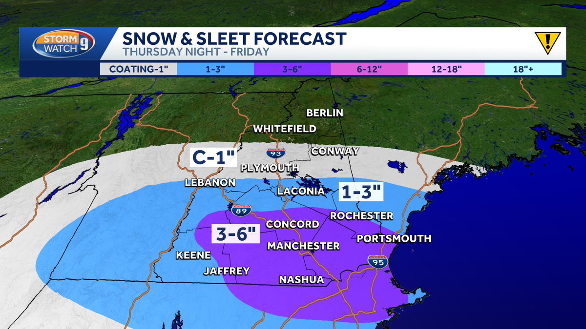
Central and southern New Hampshire will see the heaviest impacts, while areas north of Mount Washington Valley through the Great North Woods may get only a light dusting.
>> See the latest hour-by-hour timeline:
A general 1 to 3 inches of snow is forecast for most areas south of the White Mountains, with some southern spots, especially south of the Lakes Region, expected to receive 3 to 6 inches.
SNOW, WINTRY MIX FRIDAY MORNING
Roads will remain hazardous Friday morning, with slick spots likely affecting the commute.
The steadiest precipitation is expected through 7 to 8 a.m., with spotty light drizzle or freezing drizzle possible later in the morning as clouds linger.
Temperatures will stay cold Friday, with highs in the 30s, before warming over the weekend.
Be weather aware! Download the WMUR app and turn on push notifications. You can choose to receive weather alerts for your geolocation and/or up to three ZIP codes. In addition, you can receive word when precipitation is coming to your area.
Get storm coverage through the free Very Local app on your smart TV.
Follow the Storm Watch 9 team on social media: