Strong storms have brought tornado and severe thunderstorm warnings as they tracked across the state Thursday night and continue Friday morning.>> Go to the KOCO weather page | Get KOCO on the Go | Subscribe to KOCO 5’s YouTube channel | Sign up for KOCO 5’s Morning NewsletterKOCO 5 Chief Meteorologist Damon Lane says rounds of storms are expected Friday morning before another round later Friday.Below is running blog of updates from Thursday and Friday morning:12:25 a.m. Friday Update:The National Weather Service has issued a severe thunderstorm warning for southeastern Woods County, Alfalfa County and Major County.The main threat with the storms is 60 mph wind gusts.Areas that could be impacted include Fairview, Cherokee, Helena, Ringwood, Carmen, Cleo Springs, Goltry, Meno, Jet, Aline, Dacoma, Byron, Lambert, Orion, Orienta, Ingersoll, Great Salt Plains Lake, and Bouse Junction.The warning is set to expire at 1 a.m.12:15 a.m. Friday Update:The National Weather Service has issued a severe thunderstorm warning for northern Dewey County, southwestern Major County and southeastern Woodward County.The main threats with the storms are two-inch hail and 60 mph wind gusts.Areas that could be impacted include Taloga, Seiling, Camargo, Chester, Cestos, and Hucmac.The warning is set to expire at 1 a.m.11:45 p.m. Thursday Update:The National Weather Service has issued a severe thunderstorm warning for northwestern Custer County and southwestern Dewey County.The main threats with the storms are 60 mph wind gusts and hail the size of quarters.Areas that could be impacted include Leedey and Moorewood.The warning is set to expire at 12:30 a.m. Friday.11:30 p.m. Thursday Update:The National Weather Service has issued a severe thunderstorm warning for southeastern Roger Mills County.The main threats with the storms are 60 mph wind gusts and hail the size of quarters.Areas that could be impacted include Hammon, Strong City, and Angora.The warning is set to expire at 12:15 a.m. Friday.10:50 p.m. Thursday Update:A tornado warning remains in effect for central Grant County until 11:15 p.m.The storms will impact mainly rural areas east and northeast of Wakita.Residents in the area should take precautions now.10:45 p.m. Thursday Update:The National Weather Service has issued a tornado warning for south central Roger Mills County and northwestern Beckham County until 11:15 p.m.A tornado could touch down and ping pong sized hail is possible.Areas that could be impacted include Berlin and Dempsey.Residents in the areas affected should take precautions now.The National Weather Service has issued a severe thunderstorm warning for southern Roger Mills County and northern Beckham County.The main threats with the storms are 60 mph wind gusts and hail the size of quarters.Areas that could be impacted include Cheyenne, Sweetwater, Strong City, Berlin, and Dempsey.The warning is set to expire at 11:30 p.m.10:30 p.m. Thursday Update:The National Weather Service has issued a tornado warning for north central Grant County until 11:15 p.m.Areas that could be impacted include Wakita and Renfrow.Residents in the areas affected should take precautions now.10:25 p.m. Thursday Update:A tornado warning remains in effect for northwestern Grant County until 10:45 p.m.A tornado could touch down and the potential for hail up to the size of half dollars is possible.Arears that could be impacted include Wakita.Take precautions now.10:15 p.m. Thursday Update:The National Weather Service has issued a tornado warning for west central Beckham County until 10:45 p.m.There is the potential for tornado and for golf ball sized hail to drop.Areas that could be impacted include Erick and Texola.Take precautions now.10:10 p.m. Thursday Update:A tornado warning remains in effect for northwestern Grant County until 10:45 p.m.There is the potential for a tornado to lower and for golf ball sized hail. Areas that could be impacted include WakitaTake precautions now. WATCH: KOCO 5 Storm Chaser Jason Hill captures tornado damage near Jet10:05 p.m. Thursday Update:The National Weather Service has issued a severe thunderstorm warning for south central Roger Mills County and central Beckham County.The main threats with the storms are half dollar sized hail and wind gusts up to 60 mph.Areas that could be impacted include Sayre, Erick, Texola, Delhi, and Berlin.The warning is set to expire at 10:45 p.m.10 p.m. Thursday Update:The National Weather Service has issued a tornado warning for northwestern Grant County until 10:45 p.m.Locations that could be impacted include Wakita.Residents in the area should take precautions now.9:55 p.m. Thursday Update:The National Weather Service has issued a severe thunderstorm warning for southeastern Alfalfa County and western Grant County.The main threats with the storms are ping pong sized hail and wind gusts up to 60 mph.Areas that could be impacted include Pond Creek, Wakita, Jet, Nash, and Great Salt Plains Lake.The warning is set to expire at 10:30 p.m.9:50 p.m. Thursday Update:The National Weather Service has issued a tornado warning southwestern for Grant County until 10:30 p.m.Threats include the potential for a tornado to touch down and golf ball sized hail to drop.Areas that could be impacted include Pond Creek and Nash.Take precautions now.9:35 p.m. Thursday Update:A tornado warning remains in effect for southeastern Alfalfa County until 10:15 p.m. after a large and dangerous tornado was located 4 miles northeast of Helena at 9:32 p.m., the National Weather Service reported.Areas that could be impacted as the storms continue to track across the state include Jet and the Great Salt Plains Lake. The warning is set to expire at 10:15 p.m.Take precautions now.9:25 p.m. Thursday Updates:The National Weather Service has issued a tornado warning for southeastern Alfalfa County until 10:15 p.m.A confirmed “large and extremely dangerous” tornado was located near Helena, the National Weather Service reported.Areas that could be impacted include Helena, Jet, and Great Salt Plains Lake.Take precautions now.9:20 p.m. Thursday Update:A tornado warning remains in effect for southeastern Alfalfa County until 9:30 p.m.The National Weather Service said a radar-confirmed tornado has touched down in the area.Areas that could be impacted include Helena, with the potential for a tornado to touch down and ping pong sized hail to drop.Take precautions now.9:15 p.m. Thursday Update:A severe thunderstorm warning remains in effect for Alfalfa County until 9:45 p.m.The main threats with the storms are golf ball sized hail and 60 mph wind gusts.Areas that could be impacted include Cherokee, Helena, Carmen, Goltry, Jet, Aline, Burlington, Amorita, Byron, Lambert, Ingersoll, Great Salt Plains Lake, Driftwood, and Waldron.9:10 p.m. Thursday Update: A tornado warning remains in effect for southeastern Alfalfa County and northeastern Major County until 9:30 p.m.Areas that could be impacted include Helena, Cleo Springs, Goltry, and Aline.Take precautions now.WATCH: KOCO 5 Storm Chaser Jason Hill captures tornado in northwest Oklahoma8:50 p.m. Thursday Update:The National Weather Service has issued a severe thunderstorm warning for southeastern Roger Mills County, western Custer County and northeastern Beckham County.The main threats with the storms are ping pong sized hail and 60 mph wind gusts.Areas that could be impacted include Elk City, Hammon, Butler, Foss Reservoir, Moorewood, and Berlin.The warning is set to expire at 9:30 p.m.8:45 p.m. Thursday Update: The National Weather Service has issued a tornado warning for southeastern Alfalfa County and northeastern Major County until 9:30 p.m.Areas that could be impacted include Helena, Cleo Springs, Goltry, Aline, and Orienta.Take precautions now.8:40 p.m. Thursday Update:The National Weather Service has issued a severe thunderstorm warning for southeastern Woods County, Alfalfa County and central Major County.The main threats with the storms are ping pong sized hail and wind gusts up to 60 mph.Areas that could be impacted include Fairview, Cherokee, Helena, Carmen, Cleo Springs, Goltry, Jet, Aline, Burlington, Dacoma, Amorita, Byron, Lambert, Orienta, Ingersoll, Great Salt Plains Lake, Driftwood, Capron, and Waldron.The warning is set to expire at 9:45 p.m.8:35 p.m. Thursday Update:A tornado warning remains in effect for southeastern Woods and central Major counties until 8:45 p.m.A potential tornado and golf ball sized hail are threats with the storm.Those in and around Cleo Springs and Orienta should take precautions now.8:20 p.m. Thursday Update:A tornado warning remains in effect for southeastern Woods and Central Major counties until 8:45 p.m. Areas that could be impacted include Cleo Springs and Orienta.Take precautions now.The National Weather Service has issued a severe thunderstorm warning for southeastern Roger Mills County and northeastern Beckham County.The main threats with storms are half-dollar-sized hail and 60 mph wind gusts.Areas that could be impacted include Elk City, Sayre, Hammon, and Berlin.The warning is set to expire at 9 p.m.8:10 p.m. Thursday Update:The National Weather Service has issued a tornado warning for southeastern Major Woods County and central Major County until 8:45 p.m. Thursday.Areas that could be impacted include Cleo Springs, Orion, and Orienta.Those in the affected areas should take emergency precautions now.8 p.m. Thursday Update:The National Weather Service has issued a severe thunderstorm warning for eastern Woods County and northwestern Alfalfa County.The main threats with the storms are half-dollar-sized hail and 60 mph wind gusts.Areas that could be impacted include Alva, Burlington, Dacoma, Amorita, Byron, Avard, Ingersoll, Driftwood, Capron, and Hopeton.The warning is set to expire at 8:30 p.m.7:50 p.m. Thursday Update:The National Weather Service has issued a severe thunderstorm warning for northeastern Dewey County and western Major County.The main threats with the storms include half-dollar-sized hail and wind gusts up to 60 mph.Areas that could be impacted include Taloga, Seiling, Chester, Orion, northwestern Canton Lake, Hucmac, and Bouse Junction.The warning is set to expire at 8:30 p.m.7:35 p.m. Thursday Update:The National Weather Service has issued a severe thunderstorm warning for southwestern Roger Mills County and western Beckham County.The main threats with the storms are half-dollar-sized hail and 60 mph wind gusts.Areas that could be impacted include Cheyenne, Erick, Sweetwater, Texola, and Dempsey.The warning is set to expire at 8:15 p.m.7:25 p.m. Thursday Update:A severe thunderstorm warning remains in effect for central Dewey County until 7:45 p.m.The main threats with storms are quarter-sized hail and wind gusts up to 60 mph.Areas that could be impacted include Taloga, Seiling, Putnam, northwestern Canton Lake, and Hucmac.7:05 p.m. Thursday Update:The National Weather Service has issued a severe thunderstorm warning for north central Custer County and central Dewey County.The main threats with storms include hail the size of quarters and wind gusts up to 60 mph.Areas that could be impacted include Taloga, Seiling, Putnam, northwestern Canton Lake, and Hucmac.The warning is set to expire at 7:45 p.m.5:50 p.m. Thursday Update:The National Weather Service has issued a tornado watch for multiple Oklahoma counties until midnight.Counties included in the watch include, Beckham, Blaine, Caddo, Custer, Dewey, Ellis, Greer, Harmon, Jackson, Kiowa, Major, Roger Mills, Washita and Woodward.Below is what you need to know before the severe storms hit.Thursday Severe Weather Risk A level 3 enhanced risk has been issued for western Oklahoma. The risk zone includes Hollis, Altus, Hobart, Hinton, Seiling, Woodward, Cheyenne and Elk City. The surrounding areas stretching into the OKC metro, northern Oklahoma and the Panhandle have a level 2 slight risk. A band from Lawton and Duncan to Chickasha, Norman, Shawnee, Stillwater, Tulsa and Bartlesville have a level 1 marginal risk. Thursday Tornado Risk The highest risk is in western, west-central, central and north-central Oklahoma. The tornado index for those areas – which include Altus, Hobart, Woodward, Clinton, Enid, Alva, southwest of Ponca City and west of OKC – is 4 out of 10. The index for surrounding areas, including the OKC metro, drops to 2. Jonathan says he expects tornado warnings to be issued Thursday night. Thursday Severe Weather Timeline Storms are expected to develop in western and northwestern Oklahoma around 6 p.m., and they’ll move to the northeast. Those storms will come into west-central Oklahoma and the west side of the OKC metro from 9 p.m. to midnight. Jonathan says they’ll then cross into north-central Oklahoma from midnight to 3 a.m. Friday. Radar predictor shows supercells coming into Oklahoma from the Texas Panhandle near Hollis and Elk City around 6 p.m. before heading northeast. The supercells will form into a complex by 9-10 p.m. near Cheyenne, Woodward and Seiling. By midnight, that complex will be near Enid, Cherokee and Ponca City in northern Oklahoma. They’ll move more into Ponca City and Perry by 2 a.m. Friday before heading out of Oklahoma. Friday Severe Weather Risk There will be a lull after that wave of storms moves out of Oklahoma, but the Sooner State won’t be done with the severe weather threat on Friday. Jonathan says it’ll be quiet most of the morning until we get into the late afternoon and evening. There’s a level 3 enhanced risk in central and eastern Oklahoma, including in the OKC metro. Jonathan says there’s also a level 2 slight risk in southeastern and west-central Oklahoma and a level 1 marginal risk in far western Oklahoma. These storms also could produce large hail and tornadoes. Once the storms move out Friday night, Oklahoma will be clear of severe weather until Tuesday. Friday Tornado Risk The tornado index for Friday also increased, jumping to 6 out of 10 in eastern Oklahoma near Seminole, Stillwater, Ponca City, Bartlesville and Tulsa. Central Oklahoma, including the OKC metro, and southern, southeastern and far eastern Oklahoma have a tornado index of 4 out of 10. The tornado index weakens in west-central and far western Oklahoma. KOCO 5 First Alert Weather Team, led by Chief Meteorologist Damon Lane, has been certified by WeatheRate as providing the Most Accurate Forecast in Oklahoma City for 14 consecutive years. This outstanding achievement underscores KOCO 5’s unwavering dedication to delivering reliable weather forecasts to viewers.
Strong storms have brought tornado and severe thunderstorm warnings as they tracked across the state Thursday night and continue Friday morning.
>> Go to the KOCO weather page | Get KOCO on the Go | Subscribe to KOCO 5’s YouTube channel | Sign up for KOCO 5’s Morning Newsletter
KOCO 5 Chief Meteorologist Damon Lane says rounds of storms are expected Friday morning before another round later Friday.
Below is running blog of updates from Thursday and Friday morning:
This content is imported from Facebook.
You may be able to find the same content in another format, or you may be able to find more information, at their web site.
12:25 a.m. Friday Update:
The National Weather Service has issued a severe thunderstorm warning for southeastern Woods County, Alfalfa County and Major County.
The main threat with the storms is 60 mph wind gusts.
Areas that could be impacted include Fairview, Cherokee, Helena, Ringwood, Carmen, Cleo Springs, Goltry, Meno, Jet, Aline, Dacoma, Byron, Lambert, Orion, Orienta, Ingersoll, Great Salt Plains Lake, and Bouse Junction.
The warning is set to expire at 1 a.m.
12:15 a.m. Friday Update:
The National Weather Service has issued a severe thunderstorm warning for northern Dewey County, southwestern Major County and southeastern Woodward County.
The main threats with the storms are two-inch hail and 60 mph wind gusts.
Areas that could be impacted include Taloga, Seiling, Camargo, Chester, Cestos, and Hucmac.
The warning is set to expire at 1 a.m.
11:45 p.m. Thursday Update:
The National Weather Service has issued a severe thunderstorm warning for northwestern Custer County and southwestern Dewey County.
The main threats with the storms are 60 mph wind gusts and hail the size of quarters.
Areas that could be impacted include Leedey and Moorewood.
The warning is set to expire at 12:30 a.m. Friday.
11:30 p.m. Thursday Update:
The National Weather Service has issued a severe thunderstorm warning for southeastern Roger Mills County.
The main threats with the storms are 60 mph wind gusts and hail the size of quarters.
Areas that could be impacted include Hammon, Strong City, and Angora.
The warning is set to expire at 12:15 a.m. Friday.
10:50 p.m. Thursday Update:
A tornado warning remains in effect for central Grant County until 11:15 p.m.
The storms will impact mainly rural areas east and northeast of Wakita.
Residents in the area should take precautions now.
10:45 p.m. Thursday Update:
The National Weather Service has issued a tornado warning for south central Roger Mills County and northwestern Beckham County until 11:15 p.m.
A tornado could touch down and ping pong sized hail is possible.
Areas that could be impacted include Berlin and Dempsey.
Residents in the areas affected should take precautions now.
The National Weather Service has issued a severe thunderstorm warning for southern Roger Mills County and northern Beckham County.
The main threats with the storms are 60 mph wind gusts and hail the size of quarters.
Areas that could be impacted include Cheyenne, Sweetwater, Strong City, Berlin, and Dempsey.
The warning is set to expire at 11:30 p.m.
10:30 p.m. Thursday Update:
The National Weather Service has issued a tornado warning for north central Grant County until 11:15 p.m.
Areas that could be impacted include Wakita and Renfrow.
Residents in the areas affected should take precautions now.
10:25 p.m. Thursday Update:
A tornado warning remains in effect for northwestern Grant County until 10:45 p.m.
A tornado could touch down and the potential for hail up to the size of half dollars is possible.
Arears that could be impacted include Wakita.
Take precautions now.
10:15 p.m. Thursday Update:
The National Weather Service has issued a tornado warning for west central Beckham County until 10:45 p.m.
There is the potential for tornado and for golf ball sized hail to drop.
Areas that could be impacted include Erick and Texola.
Take precautions now.
10:10 p.m. Thursday Update:
A tornado warning remains in effect for northwestern Grant County until 10:45 p.m.
There is the potential for a tornado to lower and for golf ball sized hail.
Areas that could be impacted include Wakita
Take precautions now.
WATCH: KOCO 5 Storm Chaser Jason Hill captures tornado damage near Jet
10:05 p.m. Thursday Update:
The National Weather Service has issued a severe thunderstorm warning for south central Roger Mills County and central Beckham County.
The main threats with the storms are half dollar sized hail and wind gusts up to 60 mph.
Areas that could be impacted include Sayre, Erick, Texola, Delhi, and Berlin.
The warning is set to expire at 10:45 p.m.
10 p.m. Thursday Update:
The National Weather Service has issued a tornado warning for northwestern Grant County until 10:45 p.m.
Locations that could be impacted include Wakita.
Residents in the area should take precautions now.
9:55 p.m. Thursday Update:
The National Weather Service has issued a severe thunderstorm warning for southeastern Alfalfa County and western Grant County.
The main threats with the storms are ping pong sized hail and wind gusts up to 60 mph.
Areas that could be impacted include Pond Creek, Wakita, Jet, Nash, and Great Salt Plains Lake.
The warning is set to expire at 10:30 p.m.
9:50 p.m. Thursday Update:
The National Weather Service has issued a tornado warning southwestern for Grant County until 10:30 p.m.
Threats include the potential for a tornado to touch down and golf ball sized hail to drop.
Areas that could be impacted include Pond Creek and Nash.
Take precautions now.
9:35 p.m. Thursday Update:
A tornado warning remains in effect for southeastern Alfalfa County until 10:15 p.m. after a large and dangerous tornado was located 4 miles northeast of Helena at 9:32 p.m., the National Weather Service reported.
Areas that could be impacted as the storms continue to track across the state include Jet and the Great Salt Plains Lake. The warning is set to expire at 10:15 p.m.
Take precautions now.
9:25 p.m. Thursday Updates:
The National Weather Service has issued a tornado warning for southeastern Alfalfa County until 10:15 p.m.
A confirmed “large and extremely dangerous” tornado was located near Helena, the National Weather Service reported.
Areas that could be impacted include Helena, Jet, and Great Salt Plains Lake.
Take precautions now.
9:20 p.m. Thursday Update:
A tornado warning remains in effect for southeastern Alfalfa County until 9:30 p.m.
The National Weather Service said a radar-confirmed tornado has touched down in the area.
Areas that could be impacted include Helena, with the potential for a tornado to touch down and ping pong sized hail to drop.
Take precautions now.
9:15 p.m. Thursday Update:
A severe thunderstorm warning remains in effect for Alfalfa County until 9:45 p.m.
The main threats with the storms are golf ball sized hail and 60 mph wind gusts.
Areas that could be impacted include Cherokee, Helena, Carmen, Goltry, Jet, Aline, Burlington, Amorita, Byron, Lambert, Ingersoll, Great Salt Plains Lake, Driftwood, and Waldron.
9:10 p.m. Thursday Update:
A tornado warning remains in effect for southeastern Alfalfa County and northeastern Major County until 9:30 p.m.
Areas that could be impacted include Helena, Cleo Springs, Goltry, and Aline.
Take precautions now.
WATCH: KOCO 5 Storm Chaser Jason Hill captures tornado in northwest Oklahoma
8:50 p.m. Thursday Update:
The National Weather Service has issued a severe thunderstorm warning for southeastern Roger Mills County, western Custer County and northeastern Beckham County.
The main threats with the storms are ping pong sized hail and 60 mph wind gusts.
Areas that could be impacted include Elk City, Hammon, Butler, Foss Reservoir, Moorewood, and Berlin.
The warning is set to expire at 9:30 p.m.
8:45 p.m. Thursday Update:
The National Weather Service has issued a tornado warning for southeastern Alfalfa County and northeastern Major County until 9:30 p.m.
Areas that could be impacted include Helena, Cleo Springs, Goltry, Aline, and Orienta.
Take precautions now.
8:40 p.m. Thursday Update:
The National Weather Service has issued a severe thunderstorm warning for southeastern Woods County, Alfalfa County and central Major County.
The main threats with the storms are ping pong sized hail and wind gusts up to 60 mph.
Areas that could be impacted include Fairview, Cherokee, Helena, Carmen, Cleo Springs, Goltry, Jet, Aline, Burlington, Dacoma, Amorita, Byron, Lambert, Orienta, Ingersoll, Great Salt Plains Lake, Driftwood, Capron, and Waldron.
The warning is set to expire at 9:45 p.m.
8:35 p.m. Thursday Update:
A tornado warning remains in effect for southeastern Woods and central Major counties until 8:45 p.m.
A potential tornado and golf ball sized hail are threats with the storm.
Those in and around Cleo Springs and Orienta should take precautions now.
8:20 p.m. Thursday Update:
A tornado warning remains in effect for southeastern Woods and Central Major counties until 8:45 p.m.
Areas that could be impacted include Cleo Springs and Orienta.
Take precautions now.
The National Weather Service has issued a severe thunderstorm warning for southeastern Roger Mills County and northeastern Beckham County.
The main threats with storms are half-dollar-sized hail and 60 mph wind gusts.
Areas that could be impacted include Elk City, Sayre, Hammon, and Berlin.
The warning is set to expire at 9 p.m.
8:10 p.m. Thursday Update:
The National Weather Service has issued a tornado warning for southeastern Major Woods County and central Major County until 8:45 p.m. Thursday.
Areas that could be impacted include Cleo Springs, Orion, and Orienta.
Those in the affected areas should take emergency precautions now.
8 p.m. Thursday Update:
The National Weather Service has issued a severe thunderstorm warning for eastern Woods County and northwestern Alfalfa County.
The main threats with the storms are half-dollar-sized hail and 60 mph wind gusts.
Areas that could be impacted include Alva, Burlington, Dacoma, Amorita, Byron, Avard, Ingersoll, Driftwood, Capron, and Hopeton.
The warning is set to expire at 8:30 p.m.
7:50 p.m. Thursday Update:
The National Weather Service has issued a severe thunderstorm warning for northeastern Dewey County and western Major County.
The main threats with the storms include half-dollar-sized hail and wind gusts up to 60 mph.
Areas that could be impacted include Taloga, Seiling, Chester, Orion, northwestern Canton Lake, Hucmac, and Bouse Junction.
The warning is set to expire at 8:30 p.m.
7:35 p.m. Thursday Update:
The National Weather Service has issued a severe thunderstorm warning for southwestern Roger Mills County and western Beckham County.
The main threats with the storms are half-dollar-sized hail and 60 mph wind gusts.
Areas that could be impacted include Cheyenne, Erick, Sweetwater, Texola, and Dempsey.
The warning is set to expire at 8:15 p.m.
7:25 p.m. Thursday Update:
A severe thunderstorm warning remains in effect for central Dewey County until 7:45 p.m.
The main threats with storms are quarter-sized hail and wind gusts up to 60 mph.
Areas that could be impacted include Taloga, Seiling, Putnam, northwestern Canton Lake, and Hucmac.
7:05 p.m. Thursday Update:
The National Weather Service has issued a severe thunderstorm warning for north central Custer County and central Dewey County.
The main threats with storms include hail the size of quarters and wind gusts up to 60 mph.
Areas that could be impacted include Taloga, Seiling, Putnam, northwestern Canton Lake, and Hucmac.
The warning is set to expire at 7:45 p.m.
5:50 p.m. Thursday Update:
The National Weather Service has issued a tornado watch for multiple Oklahoma counties until midnight.
Counties included in the watch include, Beckham, Blaine, Caddo, Custer, Dewey, Ellis, Greer, Harmon, Jackson, Kiowa, Major, Roger Mills, Washita and Woodward.
This content is imported from Facebook.
You may be able to find the same content in another format, or you may be able to find more information, at their web site.
Below is what you need to know before the severe storms hit.
Thursday Severe Weather Risk
A level 3 enhanced risk has been issued for western Oklahoma. The risk zone includes Hollis, Altus, Hobart, Hinton, Seiling, Woodward, Cheyenne and Elk City.
The surrounding areas stretching into the OKC metro, northern Oklahoma and the Panhandle have a level 2 slight risk. A band from Lawton and Duncan to Chickasha, Norman, Shawnee, Stillwater, Tulsa and Bartlesville have a level 1 marginal risk.

Thursday Tornado Risk
The highest risk is in western, west-central, central and north-central Oklahoma. The tornado index for those areas – which include Altus, Hobart, Woodward, Clinton, Enid, Alva, southwest of Ponca City and west of OKC – is 4 out of 10.
The index for surrounding areas, including the OKC metro, drops to 2.
Jonathan says he expects tornado warnings to be issued Thursday night.

Thursday Severe Weather Timeline
Storms are expected to develop in western and northwestern Oklahoma around 6 p.m., and they’ll move to the northeast.
Those storms will come into west-central Oklahoma and the west side of the OKC metro from 9 p.m. to midnight. Jonathan says they’ll then cross into north-central Oklahoma from midnight to 3 a.m. Friday.

Radar predictor shows supercells coming into Oklahoma from the Texas Panhandle near Hollis and Elk City around 6 p.m. before heading northeast. The supercells will form into a complex by 9-10 p.m. near Cheyenne, Woodward and Seiling.

By midnight, that complex will be near Enid, Cherokee and Ponca City in northern Oklahoma. They’ll move more into Ponca City and Perry by 2 a.m. Friday before heading out of Oklahoma.

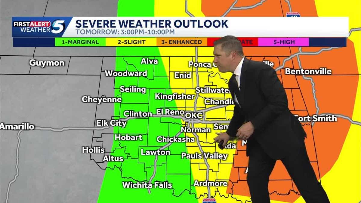
Friday Severe Weather Risk
There will be a lull after that wave of storms moves out of Oklahoma, but the Sooner State won’t be done with the severe weather threat on Friday. Jonathan says it’ll be quiet most of the morning until we get into the late afternoon and evening.
There’s a level 3 enhanced risk in central and eastern Oklahoma, including in the OKC metro. Jonathan says there’s also a level 2 slight risk in southeastern and west-central Oklahoma and a level 1 marginal risk in far western Oklahoma.

These storms also could produce large hail and tornadoes. Once the storms move out Friday night, Oklahoma will be clear of severe weather until Tuesday.
Friday Tornado Risk
The tornado index for Friday also increased, jumping to 6 out of 10 in eastern Oklahoma near Seminole, Stillwater, Ponca City, Bartlesville and Tulsa.
Central Oklahoma, including the OKC metro, and southern, southeastern and far eastern Oklahoma have a tornado index of 4 out of 10. The tornado index weakens in west-central and far western Oklahoma.

KOCO 5 First Alert Weather Team, led by Chief Meteorologist Damon Lane, has been certified by WeatheRate as providing the Most Accurate Forecast in Oklahoma City for 14 consecutive years. This outstanding achievement underscores KOCO 5’s unwavering dedication to delivering reliable weather forecasts to viewers.